Sukachev Institute of Forest, SB RAS, Krasnoyarsk
Head of the Institute:
Eugene A.Vaganov,
Akademgorodok, Krasnoyarsk, 660036, Russia
Tel.: (3912) 494092, Fax: (3912)433686
email: san@maps.ifor.krasnoyarsk.su,
ifor@.krsk.infotel.ru
Principal researchers:
A.I.Sukhinin, Head of the Department of Remote Sensing Methods of Forest Investigation
Project objectives
To develop GIS technologies for predicting, monitoring, and preventing natural disastrous events, such as forest fire, floods, hurricanes, vegetation decay due to drought and insect outbreaks, in Eastern Siberia.
Background and significance of objectives
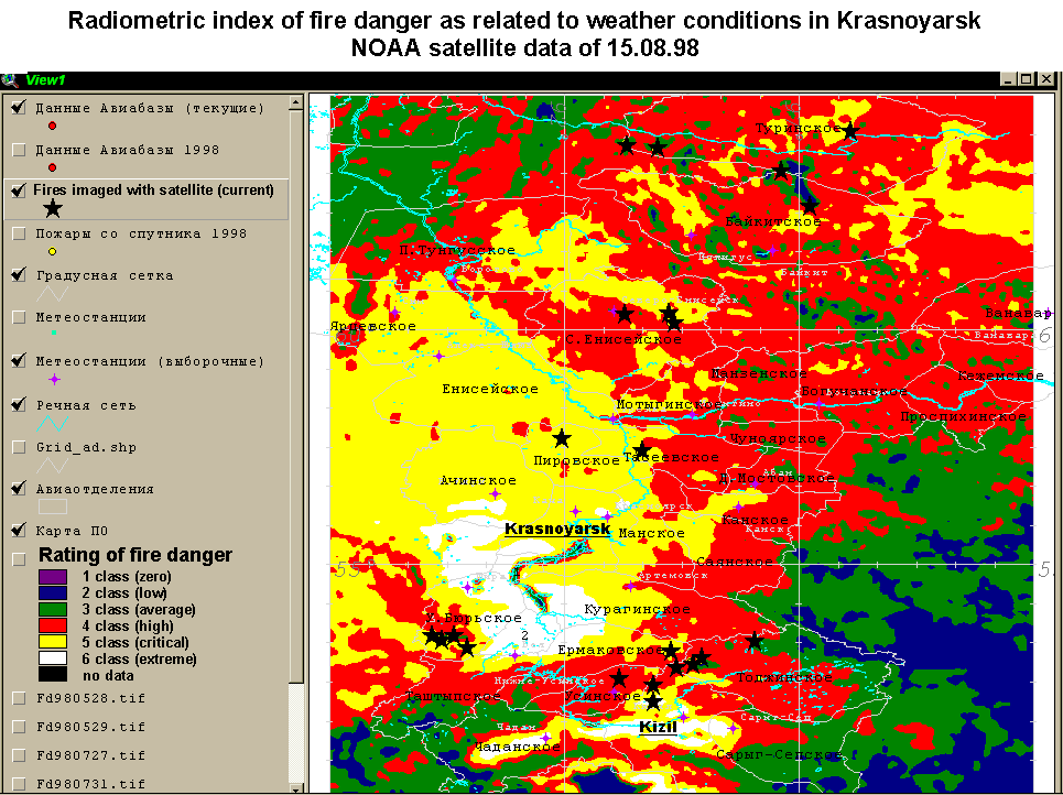
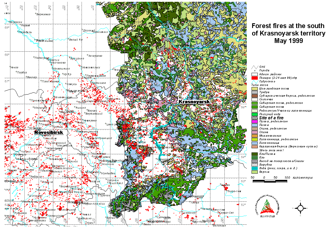
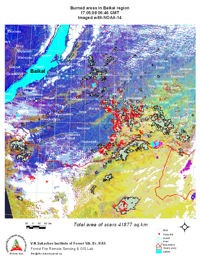
The Institute of Forest has gained more than 20-year experience in developing fundamental approaches to monitoring forest ecosystems from the air and space. During this period, the model remote sensing system “Prognose” has been designed to monitor forest fires and estimate fire hazard. The system provides quick transfer of visible, infra-red and microwave information from spacecraft and aircraft to a dispatching unit, where forest fire occurrence, spread, and growth are predicted by computer methods. These predictions are then used in fire fighting decision-making.
“Prognose” incorporates:
- a subsystem for quick reception and processing of digital information coming from NOAA-12, 14, and 15 (a Quorum COM downlink was installed by NASA in the Institute of Forest in 1994);
- an airborne subsystem for monitoring forest fires in IR and MW spectral bands (the airborne measuring complex Aerial Forest Fire Patrol was developed in 1989 to be used in AN-30 aircraft);
- a computerised command/dispatching unit to effectively carry out fire fighting operations (the unit has been in operation in the Krasnoyarsk Forest Protection Air Base since 1992).
A set of original mathematical methods and algorithms was developed that allow the system to operate in the interactive mode. These are methods and algorithms for:
- forest fire danger rating;
- calculating forest fire parameters on the basis of fuel and weather data;
- calculating the fire front spread rate from IR images;
- choosing appropriate methods to contain surface fires.
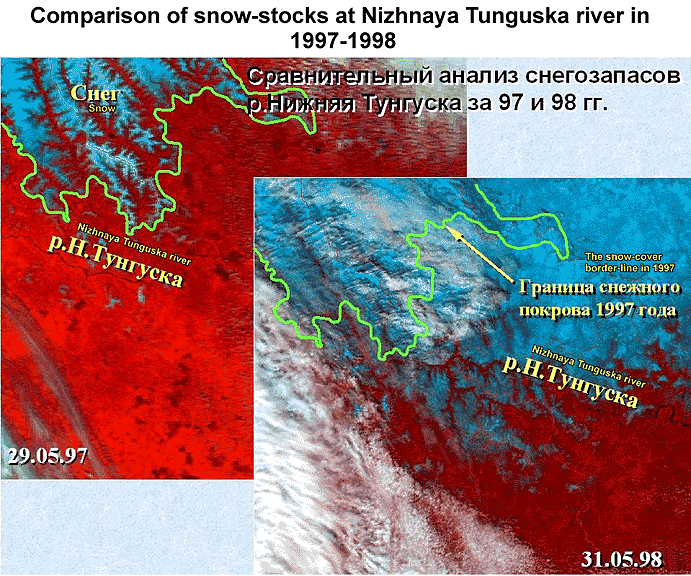
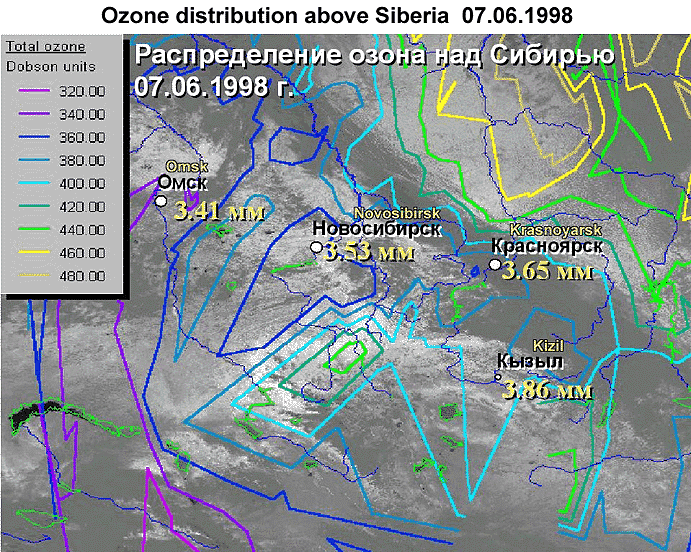
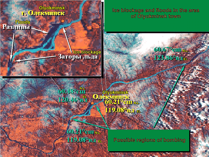
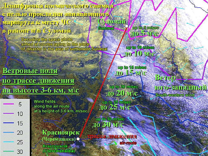
The Institute, in cooperation with the Krasnoyarsk Hydrometeorology Service and Russian EMERCOM is now actively using already available and developing new methods to predict hydrological and weather situations using NOAA information. NOAA data-based analysis of vertical profiles of atmospheric parameters (air temperature, humidity, pressure, wind, clouds, precipitation, ozone content, etc.) enables prediction and estimation of storm events. Monitoring of snowmelt dynamics combined with the use of existing models allows changes of ice and flood situations to be predicted and tracked.
A research project is now underway at the Institute aimed at developing a system to receive multi-band information from EOS-AM1 American satellite to be used for evaluating vegetation state and productivity. This is a joint project with NASA and the Krasnoyarsk Electron Research Company.
We identified predictors that, when combined with NOAA data, allow to early detect insect outbreaks. Satellite indications are refined using data from plane flights and ground investigations conducted at the Institute field stations established along the Yenisei transection.
Expected results
1. New regional models and software to predict disastrous events from spaceborne, airborne and ground information and to help reduce fire risk and mitigate negative effects of fires, floods, hurricanes, and insect outbreaks.
2. Timely supply of reliable information on current fire and flood situations and disaster predictions to local EMERCOM administrations across the Krasnoyarsk region.
3. A model of a remote sensing system for monitoring natural disasters in Eastern Siberia (the system is planned to be installed in Krasnoyarsk).
A methodology/software package to be distributed among other regional agencies (the Russian Far East, Yakutia, Buryatia, Altai, and Western Siberia) engaged in managing natural disasters by methods of remote sensing.
List of publications of participants related to the project
-
Sukhinin A.I. and Khrebtov B.A. A Technique to Estimate Forest Fire. Patent of the Russian Federation A62 C 3/02, No.1621958. May 25, 1993.
-
Sukhinin A.I. A Method of Forest Fire Danger Rating. Patent of the Russian Federation A62 C 3/02, No.1648505. August 4, 1993.
-
Sukhinin A.I. Probability to detect forest fires using methods of remote sensing // Forest Fire Fighting. Krasnoyarsk: VNIIPOMleskhoz Publ, 1994. – P. 56-69.
-
Sukhinin A.I. A system of spaceborne forest fire monitoring in Krasnoyarsk region // Siberian Journal Ecological. – 1996. – ą 1. – P. 85-91.
-
Sukhinin A.I. An information technology for forest fire danger rating // Monograph Fire in Ecosystems of Boreal Eurasia / Ed. J.G. Goldammer. – London: Kluwer Academic Publishers, 1996. – P. 277-284.
-
Kashkin V.B., Sukhinin A.I., Romasko V.Yu., Salnikova O.E. Ozone layer over Siberia as seen in IR NOAA images obtained in summer 1995 // Earth Investigation from Space. – 1997. – ą 5. – P. 93-96.
-
Sukhinin A.I. Krasnoyarsk spaceborne subsystem of forest fire monitoring as an integral part of the global fire management system // Proc. Int. Conference on Communication and Navigation Satellite Systems. Vol.3. Krasnoyarsk University Publ. 1997. – P. 112-121.
-
Vaganov E.A., Furyaev V.V. and Sukhinin A.I. Fire in Siberian taiga forest // J. Nature. – 1998. – ą 7. – P. 51-62.
-
Sukhinin A.I., Kashkin V.B. and Romasko V.Yu. Postfire forest area inventory based on satellite data // Earth Investigation from Space. – 1998. – ą 6. – P. 99-103.