
Institute of General and Experimental Biology, SB RAS, Ulan-Ude
Head of the Institute:
Vladimir M.Korsunov., Doctor of Biological Sciences, Professor
6 Sakhyanovoy Str., Ulan-Ude, 670047, Russia
fax: (3012) 330134
email: ioeb@bsc.buriatia.ru
Principal researchers:
A.I.Kulikov
N.B.Badmaev
Ã.¿.Kulikov
V.A.Tarmaev
Project objectives
The purpose of the project is to estimate features spatial – temporary reactions of geosystems of Northern Asia (from Arctic Region up to Goby deserts) on global changes, accepting thus capacity and profile of a layer of seasonal thawing of cryolithozone soils and, especially, humus layer in it as diagnosts of a climate of the past and to develop the forecast of the response for global changes of a climate using modern methods of mathematical statistics, electrosounding, of the cryolithological analysis and radioisotope (C14) of dating.
Background and significance of objectives
The active layer, and in long-term cryolithozone is a seasonalmelt layer – integrated parameter of soil-climatic conditions of territories. The seasonalmelt layer is rather dynamical in space and time on capacity and heat energetic condition to serve as a diagnostic criterion of estimation of global change of a climate. We have made a databank on the capacity of seasonal thawing of cryolithozone soils of Transbaikalia, Yakutia, and also Mongolia. In the world and domestic science there is experience in geocryological monitoring, including the active layer, in Alaska and Canada. In Russia long-term research of frozen-thermal conditions of the active layer (in essence monitoring) are carried out by a network of hydrometeostations. In the Baikal Region the long-term observation of hydrothermics and heatenergetics of the active layer is carried out at soil stations of the IGEB, SB RAS. In the context of the theme the project requires appropriate joint collective analysis and generalisation the materials of frozen stations of Institute of Frostscience, SB RAS. In the region there are unique data on the XVIII-XIX centuries and on the beginning of the XX century on cryology and thermics of the active layer. Of special interest is material received with inspection of lake Baikal around the railway and data of expeditions of Pereselenchesky management, which meet the scientific requirements. It is important to emphasise that in archival and field reported records of the researchers of that time the geographical co-ordinates (about minutes) are specified, which essentially facilitates their identification on district and opportunity of repeated study in rigid binding. The cryolithological analysis, especially with C14- by dating, the so-called retinizationing humus, fixing depth of soil thawing in the previous epoch, in correlation with dendrochronology, revealing paleogeographycal conditions of the Northern Asia for the last 1.5 thousand years (Vaganov etc., 1998) will be a basis for analysing spatial – temporary estimation of the global change of theclimate from tundra landscapes from Arctic Region to Goby Deserts of Mongolia.
Research plan: approaches and methods
The achievement of the purpose of research is possible with extended use of the known principle of actualism and especially constructive application of the concept ìsoil – memoryî (Sokolov, Targuliyan, 1975), which in our case is treated as follows. The cryolithological structure of soil profile is such that in it the attributes of ancient changes in external conditions are always kept, first of all it is possible to fix such portrait characteristics of the past as humus layer or humus crack material. The ratio of retinizationing and inside crack material of activity C14 of humus of aromatic nucleus and aliphatic part allows of a possibly adequate paleogeographical reconstruction. The use of humus reconstruction with helps of M.I. Dergacheva method (1990) is suggested. The ìprofile-portraitî reconstruction of paleolandscapes conditions is impossible to do without broader information about the climate of ancient times, which is fixed in tree-rings, layers of ice and sediment accumulations, which have the rather high temporary sanction (Kondratiev, Johanssen, 1984; Pryvalsky, 1993; Brabley, Eddy, 1989; Brabley, Jones, 1993; Baumgartner, 1989; Vaganov, Shiyatov, Mazepa, 1996; Vaganov etc., 1998), The extensiveness of territory compels and allows to use a cartographical method of researches (Berlyant, 1978, 1986), and the complexity of associations in geosystem – information and logical analysis (Puzachenko, Moshkin, 1969; Kulikov, 1991) and modern methods of analysis of cartographical information, and also informative-cartometrical estimation (Badmaev et al., 1999). The region provides plenty of long row hydrometeorological information [primarily hydrometeostations of Troitskosavsk (Kyakhta), Verkhneudinsk (Ulan-Ude) and Novoselenginsk were opened in the 80s of the last century] will be processed for revealing trends and correlation (methods of step-by-step smoothing, spectral analysis) with humus-cryolithological and soil-genetic data for actualistic reconstruction.
So, the methods of geographical actualism and comparative ecology, cryolithilogical and soil-genetic analysis and radiocarbon dating are used.
Expected results
The successful sanction of an object in view will allow us to reveal data on meteostations climatic trends at different latitudes of the Northern Asia on the meridian Novosibirsk Islands ñ Verkhoyansk ñ Yakutsk ñ Ulan-Ude ñ Novoselenginsk ñ Kyakhta ñ Ulan-Bator ñ Dalan-Dzadagad, responses (correlative dependence) as a change of capacity seasonal thawing-freezing of soils. The study of element-chemical structure of retinizated and inside cracks of different generation humus material and especially cryolithological analysis and analysis of the radioisotope structure of structural parts of humus (aromatic nucleus and aliphatic functional groups) will allow us to reconstruct ancient conditions and to give the forecast of the response of geosystems to global changes in the extensive territory of the Northern Asia.
List of publications of participants related to the project
-
Kulikov A.I. Seasonal thawing of frost soils of Transbaikalia // Soil science. ñ 1987. ñ π 4. ñ –. 41-47.
-
Kulikov A.I. Features of heat cycle in frost and seasonalfrost soils // Geography and natural resources. ñ 1988. ñ π 3. ñ P. 149-152.
-
Kulikov A.I. Hydrothermal interaction of frost and soil // News of SB USSR Acad.Sci. A series of biological sciences. ñ 1990. ñ Iss.3. ñ P. 115-120.
-
Kulikov A.I. Ecology of soils and informative estimation of connections in system soil – environment // Soil Science. ñ 1991. ñ π 11. ñ P. 133-141.
-
Kulikov A.I., Dugarov V.I. Heat cycle in soils and its components // Soil science. ñ 1987. ñ π 7. ñ P. 54-62.
-
Kulikov A.I. Spatial frost-hydrothermical microcontrasts in a soil cover // Soil science. ñ 1997. ñ π 4. ñ P. 505-509.
-
Kulikov A.I., Dugarov V.I, Badmaev N.B. Hydrothermics of slope soils of Transbaikalia // Geography and natural resources. ñ 1991. ñ π 4. ñ P. 69-76.
-
Kulikov A.I., Andrianova L.V., Nikhileeva T.P. Statistical models of a structure and properties of soils of Transbaikalia and their numerical classification for the applied purposes (on an example of hydrothermal parameters). ñ Ulan-Ude, 1993. ñ 63 p.
-
Kulikov A.I., Dugarov V.I., Korsunov V.M. Frozen soils: ecology, heat energetics and forecast of productivity. ñ Ulan-Ude, 1997. ñ 312 p.
-
Badmaev N.B., Dugarov V.I. Katens of Transbaikalia: morphology, property, heatmoisture-providing // Soil science. ñ 1991. ñ π 11. ñ P.70-79.
-
Badmaev N.B. A classificationing estimation of a thermal regime of frozen katens of Transbaikalia // Soil science. ñ 1995. ñ π 9. ñ P. 1109-1114.
-
Badmaev N.B. A regime and balance of a moisture in soil toporows of Vitim plateau // Soil science. ñ 1997. ñ π 7. ñ P. 857-863.
-
Badmaev N.B., Korsunov V.M., Kulikov A.I. Heatmoisture-providing of slope soils. ñ Ulan-Ude, 1996. ñ 137 p.
-
Badmaev N.B., Kulikov A.I. Frozen regime of katens of Vitim plateau // Geography and natural resources. ñ 1996. ñ π 2. ñ P. 112-115.
-
Badmaev N.B. et al. Informative-cartometrical estimation of soil variety of cryoaridic landscapes of Transbaikalia // Geography and natural resources. ñ 1999. ñ π 3 (in print).
-
Badmaev N.B., Kulikov A.I. An ecological estimation and mapping of frozen soils of landscapes of Transbaikalia // the Bulletin BSU: a series geographical. Ulan-Ude, 1997.
-
Buryatiya. Natural resources / Badmaev N.B., Korsunov V.M., Kulikov A.I. et al. Ulan-Ude, 1997. ñ 318 p.
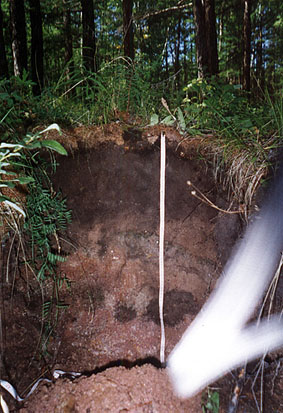
Fig. 1. A portrait illustration of structure of frozen soddy gley soils, where frozen retinization of humus are clearly displayed in the bottom part of section, of which substrate is subject to paleoreconstructions.
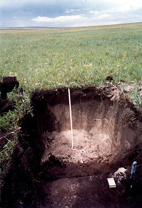
Fig. 2. A portrait illustration of anisotropy of the genetic structure of frozen swampy gley soils. Distinctly visible are streaks, giving in to the cryolithological analysis and dating.